.png)
TL;DR — We’re proud to share that Clarity has become the second commercial PM2.5 air quality sensor to be approved for inclusion on the AirNow Fire and Smoke Map (FASM), following years of technical collaboration and data validation alongside U.S. Environmental Protection Agency (EPA) and U.S. Forest Service (USFS) scientists and public health experts. This is a significant step forward not only for Clarity but for all of the communities, researchers, and agencies who rely on FASM for accurate, real-time air quality data during wildfire events. In recognition of our inclusion on FASM, Clarity's Fire & Smoke Promotion offers limited-time discounts on our wildfire-oriented air quality monitoring equipment.
The Fire and Smoke Map (FASM) is a public tool developed by the U.S. Environmental Protection Agency (EPA) and U.S. Forest Service (USFS) to deliver timely information about air pollution—specifically particulate matter (PM2.5) levels—during wildfires. It integrates air quality data from permanent government monitors, temporary emergency sensors, satellite imagery, smoke plume modeling, and—until recently—just one network of commercial low-cost sensors (PurpleAir). Now, Clarity joins the short list of EPA-approved low-cost air quality sensors included on the Fire and Smoke Map.
This development represents more than a technical achievement—it’s a meaningful recognition of the real-world value that low-cost, research-grade air quality sensors can bring to public health monitoring, especially in rural, remote, or under-monitored areas. It is also a testament to the growing trust in air pollution sensors to provide timely, actionable data during crises like wildfires.
We would like to thank the EPA, first and foremost, for their collaboration and commitment to bringing accurate, real-time air quality data to communities across North America. Building a calibration model that allowed our sensors to perform reliably across a range of climates and smoke conditions took years of field testing, collaboration, and iteration. We focused on the areas where accurate data is hardest to get—when smoke concentrations are high and health risks are rising. Seeing that work validated by the EPA and put to use during real emergencies like the LA wildfires is incredibly rewarding.”
– Levi Stanton, Solutions Engineering Lead at Clarity Lab
Effective immediately, over 550 Clarity Node-S air quality sensors are now live on the Fire and Smoke Map—marking a major expansion in nationwide wildfire smoke monitoring. With nearly 500 more sensors expected to go online over the next six months, this is just the beginning of our impact on the Fire and Smoke Map.
These devices represent a wide range of deployments, from major public agencies like the Los Angeles Unified School District and Houston Health Department, to local governments like Adams County in Colorado, and grassroots environmental justice organizations such as Sequoia Foundation and Brightline Defense. This diversity in Clarity sensor deployments reflects a key strength of our model: we work directly with professionals—not individuals—to build air quality monitoring networks that are responsive to public health needs and equitable in coverage.
We’re honored to have worked with the EPA on this effort and proud to see Clarity’s network helping close critical data gaps in wildfire-prone regions. This moment is about more than just adding sensors to the Fire & Smoke Map, it’s about changing who gets access to reliable air quality information. Our mission has always been to empower the people closest to the problem—school districts, city health departments, and local organizers—with air quality data they can trust to protect their communities.”
– David Lu, Co-founder and CEO of Clarity
Clarity’s approach to air quality monitoring is built with professionals and public agencies in mind. Our Node-S air quality sensors are designed for deployment at scale, offering solar power, cellular connectivity, and rugged enclosures that make them easy to install and operate in remote or underserved locations without the need for existing infrastructure. Whether along wildfire evacuation routes, at the edge of agricultural regions, or in rural school districts, Clarity sensors are purpose-built to go where traditional monitors can’t.
Unlike networks of consumer air quality sensors that are primarily homeowner-driven and tend to be clustered in higher-income ZIP codes, networks of Clarity air quality sensors are strategically planned to fill air quality measurement gaps—especially in communities that are historically overlooked or at higher risk from air pollution.
While the Fire and Smoke Map focuses on PM2.5, Clarity’s modular air quality monitoring system also allows organizations to expand their monitoring capabilities over time, adding measurements for super-pollutants like black carbon and gases like nitrogen oxides, carbon monoxide, and ozone as needs evolve. This flexibility gives agencies and researchers the tools to build air pollution monitoring networks that are not only more accessible but also more adaptable to changing environmental challenges. In recognition of our inclusion on FASM, Clarity's Fire & Smoke Promotion offers limited-time discounts on our wildfire-oriented air quality monitoring equipment.
The journey to EPA-approved Clarity data: A public-private partnership years in the making
Clarity’s inclusion on the Fire and Smoke Map reflects a shared commitment to better public access to air quality information. Since 2022, our team has worked closely with the EPA to qualify Clarity Node-S air pollution sensors for inclusion on the map, ensuring that the data our sensors produce under wildfire smoke conditions meets the rigorous technical considerations required for NowCast AQI estimation.
To fine-tune sensor performance under wildfire smoke conditions, Clarity partnered with air quality monitoring agencies across the Western U.S. to deploy Node-S devices at key sites —areas where elevated PM2.5 levels were expected during fire season. These sensors were collocated with federal equivalent monitors in locations such as Northern California and Oregon, allowing the team to capture several real-world smoke events for use in refining our PM2.5 Global Calibration.
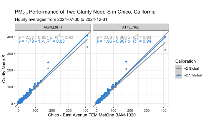
This effort culminated in the development of a new PM2.5 Global Calibration model—version 2.1—which was designed to bring out-of-the-box readings from Clarity sensors more closely in line with the accuracy of federal reference monitors. Our Lab team validated the model using a wide base of historical collocation data from smoke-impacted deployments and real-time emergency use cases. You can see the performance results from these collocations in Clarity's collocation results library.
While the main objective was to generate the comprehensive dataset required for EPA’s evaluation of Clarity sensors for the Fire and Smoke Map, the collocation effort also served as an independent dataset for assessing the performance of the v2.1 calibration. These deployments gave the team an opportunity to validate the model with fresh data not used in its initial development.
This is demonstrated by taking a look at one of the aforementioned collocations: two Clarity Node-S devices at a site managed by the California Air Resources Board in Chico, California (Figure 2). The v2 performance is already stellar, and v2.1 improves the performance statistics slightly, with the biggest improvement in accuracy observed above 100 μg/m³.
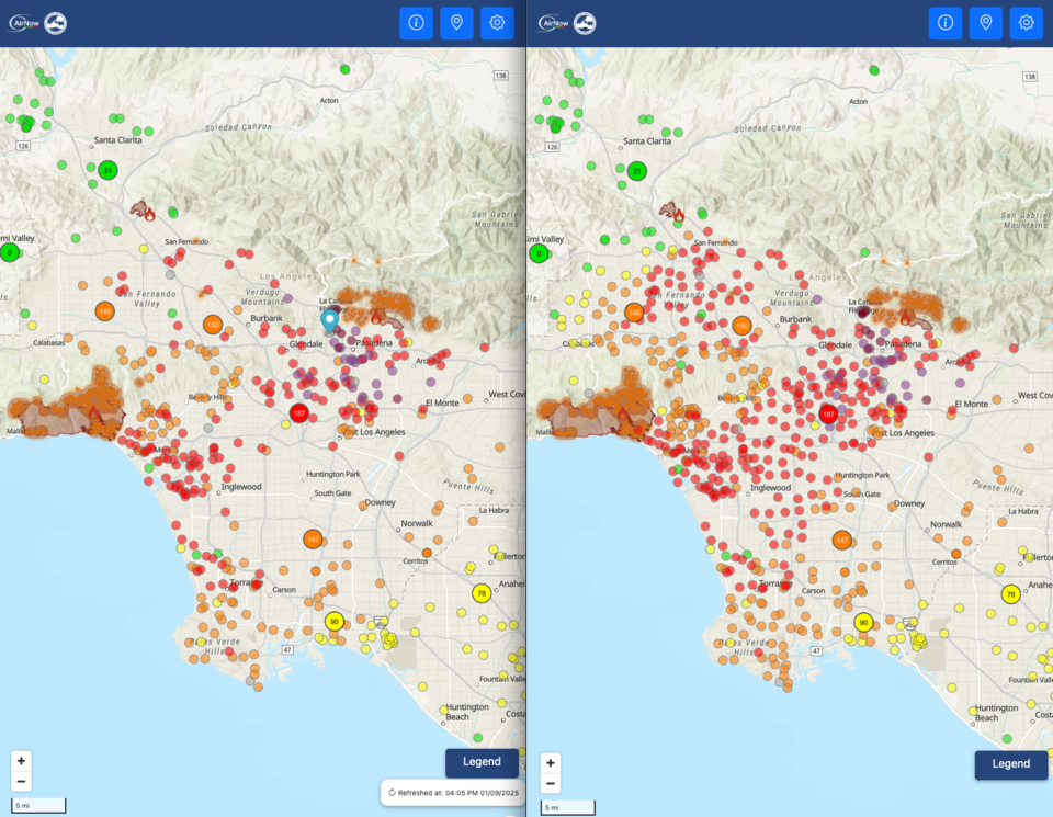
The Los Angeles Wildfires: Delivering timely air quality data when it mattered most
Clarity sensors were first displayed on the Fire and Smoke Map in January 2025, in response to the Los Angeles wildfires. At the time, the EPA added Clarity air quality sensor data as an emergency measure to bolster situational awareness in a region under severe air quality distress. With this addition, the spatial coverage of air monitoring in the LA area expanded dramatically, providing the public and first responders with more localized information to guide health decisions and resource deployment.
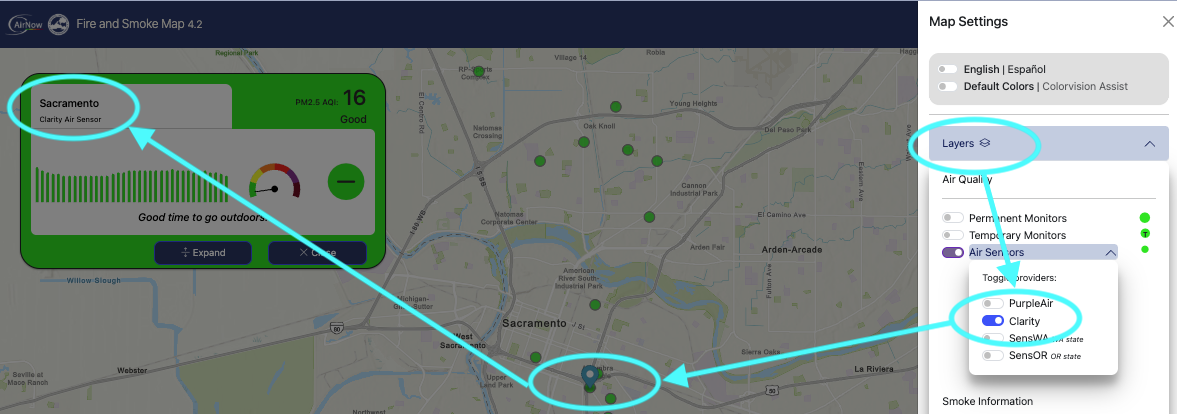
Recently, the EPA completed final testing of Clarity sensors in their internal “sandbox” environment, a key step before rolling out a new public version of the Fire and Smoke Map that includes Clarity Nodes by default. Users can now view Clarity data on the map by opening the legend and enabling the “Clarity Air Sensors” layer.
A new chapter for indicative air quality sensors
Until now, PurpleAir devices were the only low-cost sensors publicly displayed on the Fire and Smoke Map. Their inclusion in 2020 followed a pilot program involving over 70 collocation sites nationwide.
Since then, the EPA has signaled its intent to open the map to more sensor types—but only after careful validation to ensure consistency and comparability across data sources. Clarity is the first private company whose sensors have been evaluated to meet the EPA’s strict technical considerations since the initial pilot with PurpleAir.
At Clarity, we remain committed to making air quality data more accessible, more localized, and more reliable—especially in the moments when it matters most. We are grateful to the EPA, USFS, and everyone who’s worked to make the Fire & Smoke Map the valuable public resource that it is today.
If you're interested in working with Clarity, we are offerings limited-time discounts on our wildfire-oriented air quality monitoring equipment in recognition of our inclusion on FASM. Get in touch today!