
Image provided by Chris Boyer via Unsplash.
TL;DR: Wildfire activity in 2025 has varied widely around the world, with some regions facing unusually intense fire seasons. Climate change, drought, and land management practices continue to shape where and how wildfires occur. Alongside the environmental and human toll of the fires themselves, smoke from these fires remains a major contributor to poor air quality and related health risks. Checking your local AQI and taking protective measures can help reduce exposure to wildfire smoke, while addressing global warming supports long-term efforts to limit future fire risk.
In many parts of the world, wildfires have been increasing in size and intensity, largely due to global warming. Not only is this damaging to ecosystems, property, and people, but wildfire smoke also poses a significant threat to public health. Smoke contains air pollutants such as carbon monoxide and fine particulate matter, which can penetrate deep into the lungs.
With this in mind, it is worth taking a closer look at how this year’s wildfire season has been shaping up so far. How has this global warming-related issue been affecting people around the world, and what can be done about it?
Europe
Much of Europe (especially Southern Europe) has been experiencing heatwaves and drought conditions this year. Unfortunately, this has led to numerous wildfires across the continent. As of August 13th, 1,628 fires have been detected and 439,568 hectares have burned this year alone. At the same time last year, only 188,643 hectares had been burned, a significantly smaller amount.
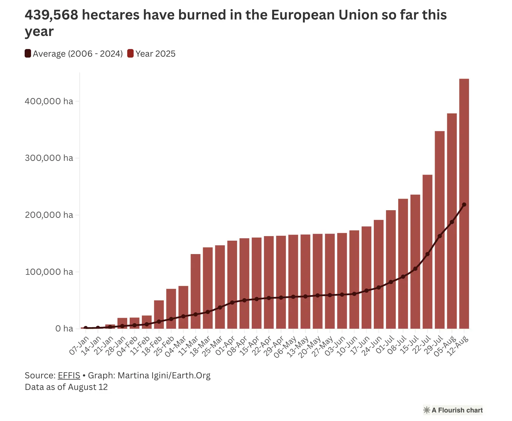
Spain and Portugal are among the countries that have experienced the most wildfire damage this year. As of August 18th, Spain alone was battling 20 major wildfires, resulting in multiple deaths, while Portugal’s forests were burned at a rate 17 times higher than in 2024.
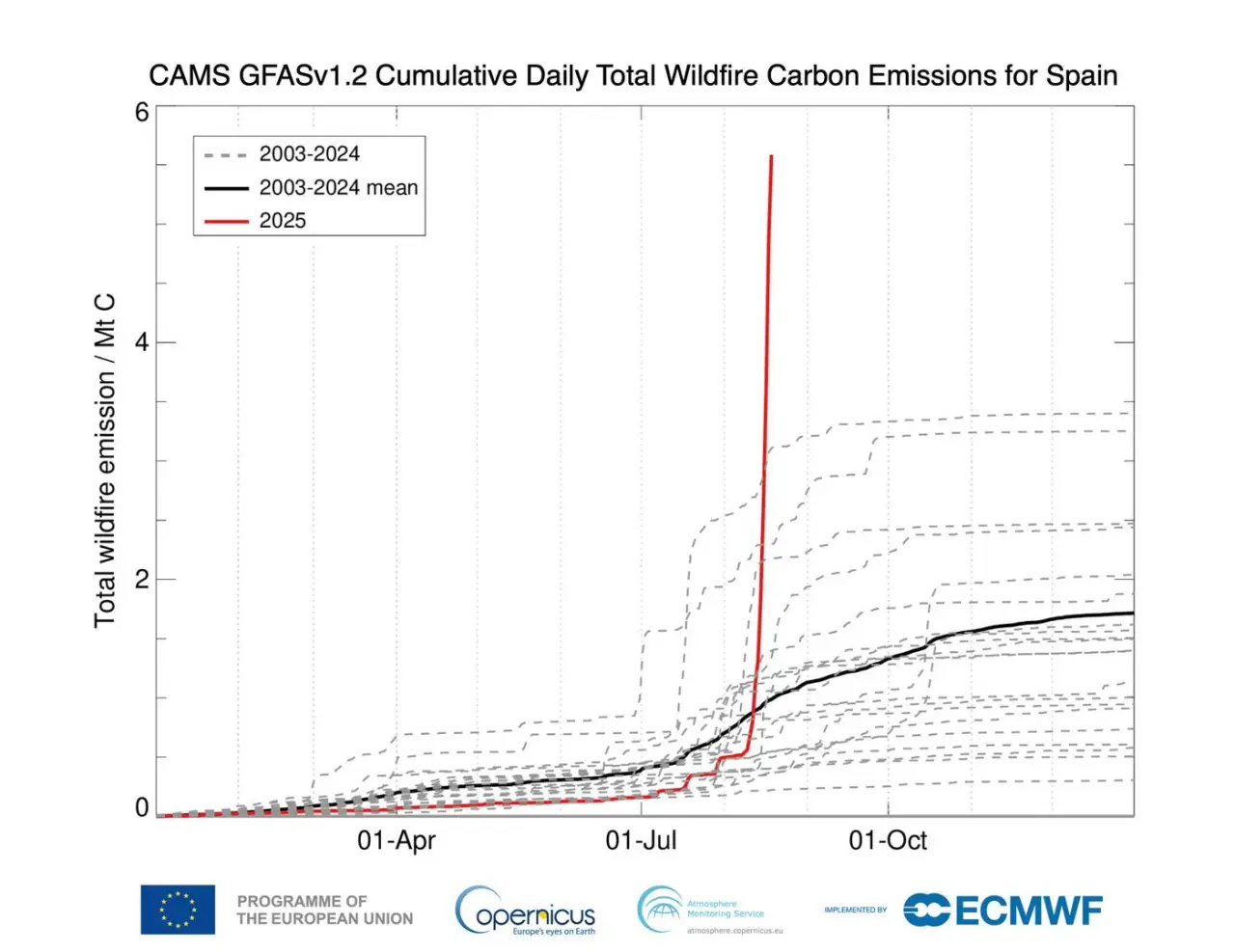
According to data from the EU’s Copernicus Atmosphere Monitoring Service (CAMS) records, as a result of a weeklong, extremely intense heatwave in Spain, the acreage of land burned — and consequently the carbon emissions associated with those wildfires — shot up nearly vertically during the week of August 11th. This demonstrates how a warming climate and the wildfires it drives can be a negative feedback loop, with warming temperatures driving more fires, and those fires contributing further to climate change.
Italy, Greece, Turkey, and the Balkans have also been affected. In early August, France saw its largest wildfire in nearly 80 years, and the UK’s 2025 wildfire season has been the worst recorded since monitoring began in 2012. Many of these fires have been connected to the climate crisis.
Asia
Different parts of Asia have experienced differing wildfire trends this year. The Upper ASEAN region (Myanmar, Thailand, Laos, Cambodia, and Vietnam) experienced a relatively low fire season during the first four months of 2025. However, fire activity was still intense during March and April in areas such as Myanmar and Laos.
Notably, efforts to reduce slash-and-burn agricultural practices in the Upper ASEAN region have significantly reduced fire-related air pollution. Unfortunately, in early 2025, South Asia experienced haze from agricultural fires and wildfires, while very dry winter conditions led to wildfires and smog in the Kathmandu valley.
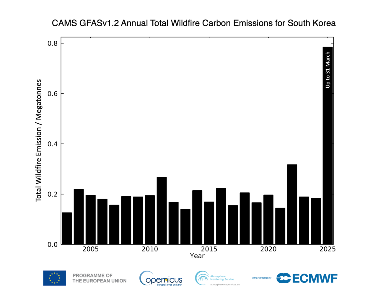
South Korea has experienced a particularly tragic wildfire season this year. Dry, hot, and windy conditions in March led to fires that killed 32 people, destroyed 5,000 buildings, and burned a total of 256,989 acres (104,000 hectares). These fires were nearly four times more extensive than South Korea’s previous worst fire season, which was 25 years ago. Climate change made these March fires twice as likely to occur, according to an attribution study.
Dry weather also led Japan to experience severe wildfires in February and March. The fires burned thousands of hectares, damaged hundreds of structures, and even took lives. Eastern Russia has also seen fire activity this year, affecting over a million hectares in April. Smoke from these fires drifted to parts of China and Japan, decreasing air quality in these areas.
Australia
Australia saw heightened fire risk for much of this year. Even during the winter, Australia had heightened fire risk in the southern coastal areas of SA and portions of western, southwestern, and southeastern Victoria due to drought conditions.
Back in January 2025 and December 2024, during Australia’s summer months, bushfires raged in parts of the Southeast. Grampians National Park and Little Desert National Park experienced fires amid hot, dry, and windy conditions. Numerous buildings and tens of thousands of hectares were burned in the blazes across Western Victoria. Many fires also burned in New South Wales.
More recently, dry conditions have sparked bushfires around the Darwin and Northern territories. For instance, one bushfire near Katherine has burnt over 2,250 km2 this August. However, this coming Spring should bring more rainfall and cooler temperatures. Even so, Northern Australia may still experience heat and fire risk.
Africa
This year, the African continent has experienced many wildfires. By June 1st, 2025, over 100 million hectares of land had burned around the world. About half of that land was in Africa, with almost 53 million hectares burned in the first half of 2025.
NASA’s satellites spotted fires in the Central African Republic in late January and in Central Africa in early July. Both times, NASA suspected that these fires may have originated from deliberate agricultural burning. Unfortunately, these kinds of fires carry many of the same health risks as naturally occurring wildfires.
In Kenya, there have been 1,076 VIIRS fire alerts reported in 2025 so far, which is within the normal range. Unfortunately, fires burned in Isiolo, an area with rare and endangered plant and animal species, harming this important ecosystem.
The Western Cape area of South Africa has seen more fires, but fewer hectares burned this wildfire season (spanning from November 2024 to April 2025) when compared to previous years. The Swartberg fire alone burned 15,545 hectares in the region.
Even the Congo Basin saw an increased likelihood of fire this year due to climate change.
South America
2024 saw very intense wildfires across numerous countries in South America, with 6.7 million hectares of rainforest burned, the highest on record, and 86 million hectares burned in South America overall. Heatwaves and droughts carried over into 2025. South America continued to experience wildfires, especially in the early months of this year.
In January, Chile faced 74 wildfires, resulting in several deaths. Argentinian Patagonia also saw wildfires early this year, causing hundreds of families to lose their homes and over 10,000 hectares of native forests to burn. Several fires have also occurred in Brazil, damaging various ecosystems and communities.
This year, Columbia actually experienced a very wet April and June. Venezuela also experienced heavy June rainfall. This led to dangerous landslides and floods in these regions. One landslide in Granizal even took 27 lives. Thus, daily bursts of rainfall can increase even in places that are experiencing more long-term drying trends.
North America
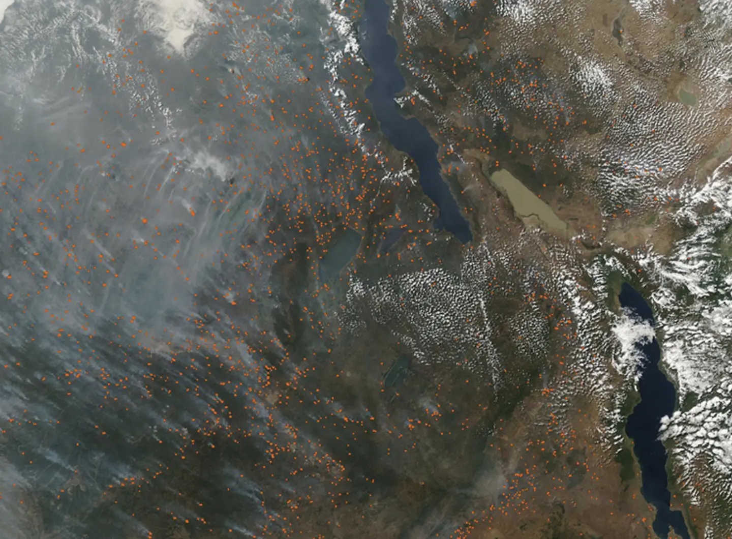
Many parts of North America have experienced a severe wildfire season this year. For Canada, this year carried the second-worst wildfire season on record, with over 7.3 million hectares burned as of August 12th, with many fires still uncontained.
Unfortunately, this is a part of a growing trend due to global warming. The last three wildfire seasons have been severe, with 2023 seeing 17.3 million hectares burned in Canada. These repeated fires can even cause forests to lose their resilience, unable to regrow in the area for years or decades.
Between January and July of this year, a total of 6,474 wildfires were recorded in Mexico. Approximately 1,117,916 hectares were burned. 2025 was the third most severe on record regarding the area affected in the first four calendar months of the year.
The United States
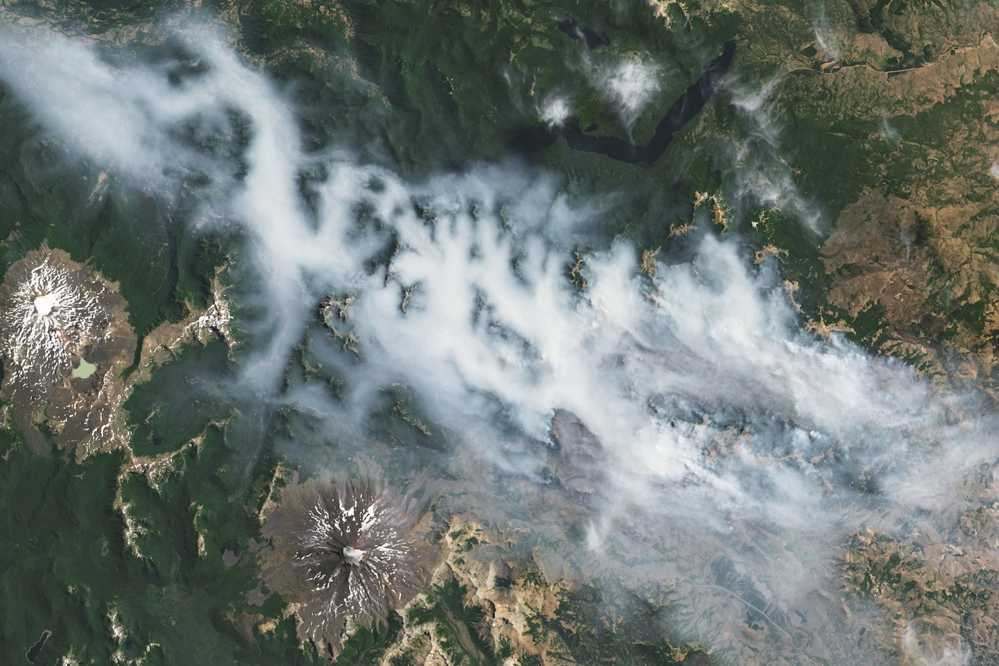
The United States has also experienced fire activity this year. In mid-May, several wildfires broke out in the Arrowhead region of Minnesota. Fortunately, these fires are now contained, although they did collectively burn over 10,000 hectares. Southwestern Utah saw over 20,000 hectares burn this June. Alaska saw 334,000 hectares burned as of mid-July, and still has some active fires across the state.
California experienced the Madre fire in July and the Gifford fire in August. The latter is 95% contained as of August 20th, and has burned over 52,600 hectares. There are still several active fires across California. Back in January, LA experienced several fires which burned 55,082 acres (or roughly 22,291 hectares), claiming 29 lives.

Oregon’s Cram fire burned 38,743 hectares. In Colorado, the Lee fire has burned over 137,755 acres (roughly 55,747 hectares) and is still ongoing as of August 20th. In Arizona, a fire erupted in early July, burning over 58,600 hectares near the North Rim of the Grand Canyon. As of August 20th, this fire is yet to be contained.
Looking forward
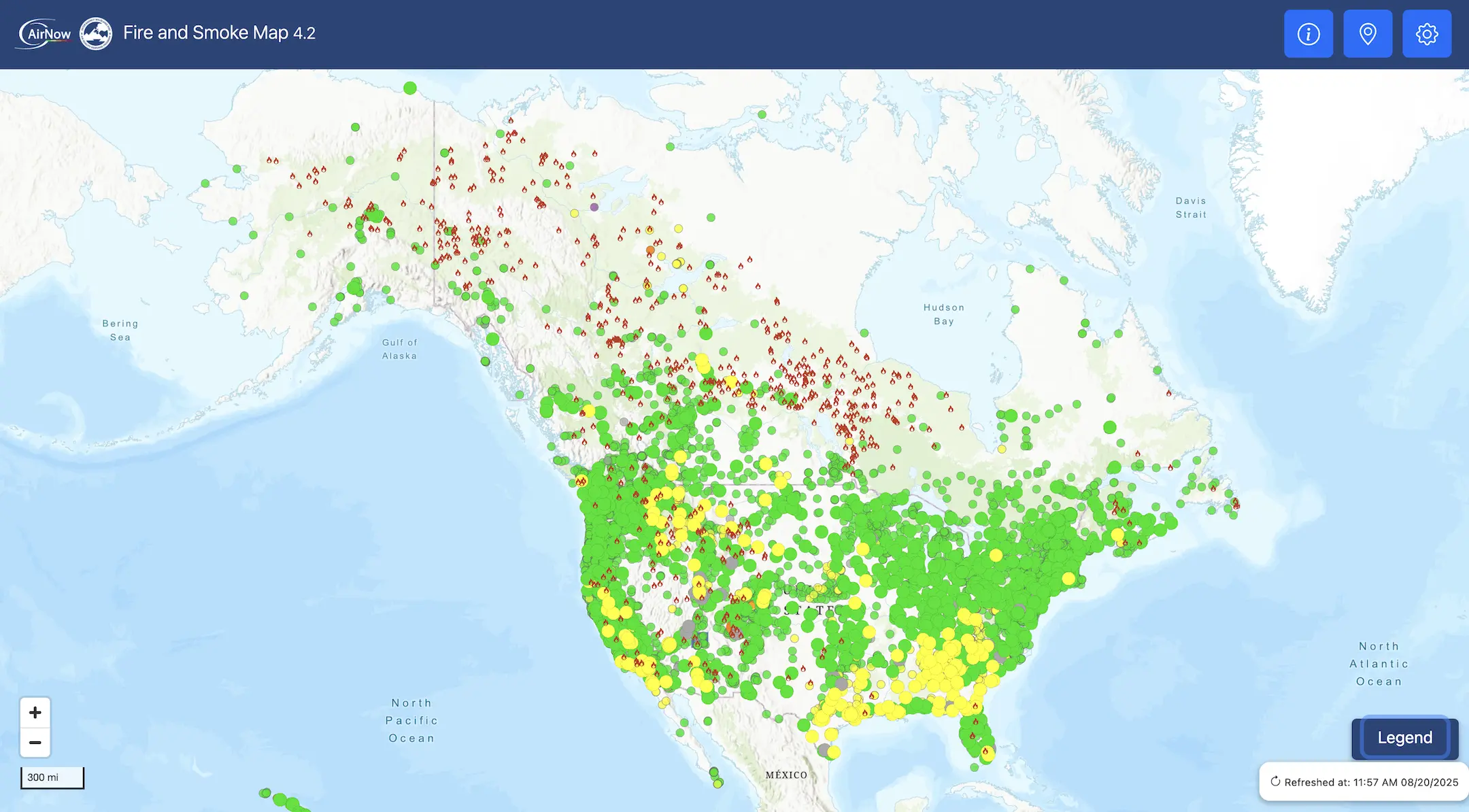
Fortunately, there are steps that we can take to protect ourselves in the face of ever-more frequent wildfires. Reduce your carbon footprint and get involved in addressing climate change. Advocate for proper land use planning. Always check your local Air Quality Index (AQI) to determine if the air is safe to breathe. Clarity’s OpenMap and AirNow’s Fire and Smoke Map both show local AQI.
Take the following precautions in the event of unsafe ambient air quality, including staying indoors and wearing a mask if you need to be outside. Be sure to take precautions if you smell smoke or see ash, even if the AQI is in the healthy range.
Investing in air quality sensors is an important way to keep communities safe from wildfire smoke air pollution. Learn how you can build a solution with Clarity. We are currently offering a discount for this year’s wildfire season.